Another geographical great was President this year. One whose work is still referenced today, and who was very prolific and started young.
Just two years after H. J. Fleure, we had another geographical 'big hitter'.
Professor (Laurence) Dudley Stamp was one of the leading lights in geography of the 20th Century, and his work is still referenced today, and some of his books are still in print and available to purchase.
He was prolific in his output, and served on a great many committees and supported the work of many different organisations. He was a real globe-trotter in an era when aircraft began to open up the world to those who could afford to use them - or who had their flights paid for.
Stamp held numerous influential posts, and had tremendous energy to publicise the importance of Geography.
He was born in 1898 in Catford, London and died in 1966 in Mexico City. A life very well lived, but which still ended a little prematurely.
He was the youngest of seven children, and his older brother was
Josiah Stamp, who was
President of the GA in 1936, who has his own post on this blog. He had poor health as a child.
I presume these are the only brothers to have been GA Presidents. I wonder whether that will ever happen again. I don't think my brother will be applying...
Stamp saw active service during the First World War, as had other Presidents in the early part of the 20th Century. This period of the GA's history is well worth further investigation I would say by those who have the appropriate connections.
The first mention of Dudley Stamp that I came across in connection with the GA is from 1924, when he is mentioned in 'The Geographical Teacher' as having started a new GA branch in Burma.
At the time he was Professor of Geology and Geography at the University of Rangoon.
This was an early foray into the work overseas carried on now, through the auspices of the International SIG of the GA and others.
Dudley Stamp was also Chief Advisor of Rural Land Use, Ministry of Agricultural between 1942 and 1955. He was appointed Commander, Order of the British Empire (C.B.E.) in 1946. He was Professor of Social Geography between 1948 and 1958 at the
London School of Economics (another former President with a strong connection to that institution which was co-founded by a previous GA President)
He was President of the International Geographic Union between 1952 and 1956
He was member of the Royal Commission on Common Land between 1955 and 1958.
He was appointed a Knight in January 1965, the year before his death, while he was
President of the Royal Geographical Society, and later the IBG.
He inspired
Bill Mead: another former
GA President, who I shall come on to later, and who referred to a lecture that he attended given by Dudley Stamp on the country of Finland, which led to his own lifelong interest in Scandinavia which was a real feature of his own Presidency.
The Land Use Survey that Dudley Stamp initiated was an important aspect of the GA's public facing work during this time, work which continues today. The GA led on several large national projects which will feature on the blog.
For more on this work, it is worth getting hold of the book that recorded the findings.
Data from this survey can also still be accessed by those in Higher or Further Education via Edina. Thanks to Edina for pursuing this for me.
https://digimap.edina.ac.uk/webhelp/environment/data_information/dudleystamp.htm - more details
1930s Land Utilisation Survey of Britain (Dudley Stamp)
You can see the Scottish sheets on the
National Library of Scotland Mapping site. They look hand drawn, which is excellent.
G. R. Crone in his chronology of the 20th Century growth of Geography says of the maps that they

Dudley Stamp's rather good Presidential Address was on the theme of
"Some neglected aspects of geography".

In it, he explores the foundations of the subject, and the development of exploration.
I liked a definition of exploration that he referred to at the time:
"Exploration at this period [earlier in the century] has been defined as the first discovery of new lands by a white man, preferably an English man, and only really authentic if sponsored by the Royal Geographical Society"
He referenced a previous GA President:
Hugh Robert Mill early in the address, along with
A. J. Herbertson.
He was concerned with the work of
P. W Bryan's work 'Man's adaptation of Nature". He described the focus on 'cultural landscapes' as a 'short-cut', which led to 'facile correlations'.
Stamp provided his own definition of geography as
"the study of the earth as the home of man".
He also waded into the idea of research in the classroom.
"How soon dare we introduce into our teaching.... the findings of research workers knowing that there is always the possibility that their results may not be confirmed by later investigations".
He also gave some nice examples of textbooks being out of date. He referred to a book that was still being used in the 1930s in schools which had been published in 1864 and was in its 122nd printing. The book stated "the turnpike roads of England are generally in good repair". The idea of textbooks being up to date is still an issue now.
Here's an image of Stamp from the 1940s
https://www.flickr.com/photos/lselibrary/4113983031/in/photolist-7gBb8U-7gxePV-fjt8aX-fjt8ex-fjt8at

In the 1950s, Stamp said he was still being asked "by biologists, when you geographers are going to make your mind up about continental drift". He wondered about the truth of some aspects of this theory, and in 1931, also mentioned weather fronts (a new idea at the time from Bergeron) as being contentious for a while, but then accepted.
It was interesting hearing him talk about the early plans for commercial flights to the USA.
He also mentions the neglect of the globe as the best way of teaching about the world's continuity.
"It is appropriate that the opening of the new HQ of the Geographical Association at Sheffield should have been marked by the presentation of a globe to adorn the library"
Where is this I wonder?
Stamp wrote a great many books during his long career.
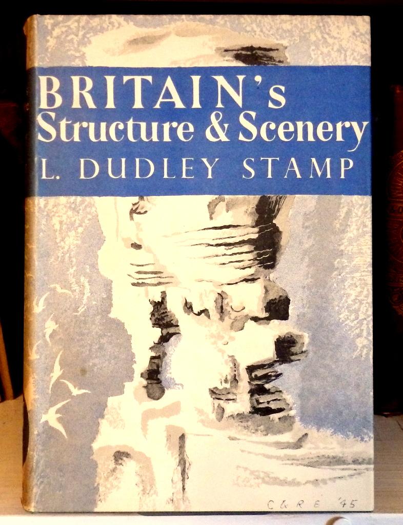
One of his most famous book covers is shown here.
He was one of the founders of the
New Naturalists series as well, which has wonderful illustrated covers.
Thanks to Brendan Conway for providing the following additional detail:
Dudley Stamp was also president of the International Geographical Union 1952–56. When the IGU met in London in 1964 he engineered a particularly high profile for the subject with this set of stamps. The themes chosen for the abstract images were curious, to say the least. It is also interesting that he should get a STAMP of course as his contribution.
I managed to get hold of some copies of the stamps via eBay for my own growing Geographical archive. I will bring them along in 2020.
Thanks also to Steve Brace for also pointing out that L Dudley Stamp appeared on
'Desert Island Discs' - sadly only a brief extract remains of Stamp being interviewed by Roy Plomley.
He may be the only Geographer to have had that privilege.
This was broadcast in 1963, and allowed Stamp to explain his Land Use Survey and the pressures on land and the use of chemicals (in the era of Rachel Carson's 'Silent Spring', and also overfishing of the oceans. Good to see that his Desert Island luxury was wine.

A year earlier he had been honoured by Poland.

Stamp was also a very prolific author of geography books.


His most significant book in terms of influence and market share was
'The World'.
This was the textbook used in many schools during the 1930s, 40s and beyond, and Rex Walford says that
"Stamp is the only geography textbook writer to have sold a million copies of a single book".
So this set me off on a bit of a journey.
I thought that perhaps David Waugh's books must have sold a million, and wanted to see whether this had now changed.
I contacted a few people at Hodder, who were involved in the publication of the Key Geography series and also GAIA. This led to quite a few e-mails going backwards and forwards.
I shall share the results of this research in a future post on the blog.
I also discovered in April 2020 that the Herbertsons sold 1.4 million copies of their books in the early part of the century.

Here's my copy - the book was in print for over 50 years.
Here's another copy of one of Stamp's books that I own. This one is called
'The Face of Britain" and is a good little read. You will find plenty of Stamp's books still in 2nd hand book shops. This book was published in 1940, and on the title page, Stamp is described as the:
Sir Ernest Cassel Reader in Economic Geography in the University of London (LSE)
 There were several notable obituaries, including one published in the journal of the American Geographical Society, and another in the Geographical Journal (written by another former GA President Michael Wise)
Updated March 2020
Balchin's Centenary volume describes how Stamp was attending an International Geographical Union Regional Conference when he died in Mexico City, after 40 years of service to the GA.
He outlines how:
"with a flat in London, a main residence in Bude, Cornwall and a country cottage in British Columbia, Sir Dudley was a "global" geographer.... he once dropped in to a GA Executive meeting at the LSE between changing planes at Heathrow on his way from Stockholm to New York. "
I'd love to find out more about his life and travels.
He certainly presaged the sort of travelling which we all became used to before the coronavirus put a halt to that in March 2020.
Source of the main image above - other image of Desert Island Discs copyright BBC.
Stamp, L. Dudley. “SOME NEGLECTED ASPECTS OF GEOGRAPHY. Address to the Geographical Association.” Geography, vol. 36, no. 1, 1951, pp. 1–14. JSTOR, JSTOR,
www.jstor.org/stable/40563084.
Walford, R. (ed) (1997), Land-Use UK: A Survey for the 21st Century. Sheffield: Geographical Association.
https://digimap.edina.ac.uk/webhelp/environment/data_information/dudleystamp.htm
https://snaccooperative.org/ark:/99166/w6tb5p4p - Biography with details of Stamp
Crone, G. R. “British Geography in the Twentieth Century.” The Geographical Journal, vol. 130, no. 2, 1964, pp. 197–220. JSTOR,
www.jstor.org/stable/1794582
Obituary:
George H. T. Kimble. “Obituary: Laurence Dudley Stamp 1898-1966.” Geographical Review, vol. 57, no. 2, 1967, pp. 246–249. JSTOR, www.jstor.org/stable/213163.
If anyone has any further details on Dudley Stamp and his legacy, please get in touch.
Updated December 2019
1961: NATHAN, LORD. “GEOGRAPHY AND THE BUSINESS WORLD TO-DAY.” Journal of the Royal Society of Arts, vol. 109, no. 5059, 1961, pp. 516–526. JSTOR,
www.jstor.org/stable/41369050. - a nice comment following the piece, which looks at the value of geography to the world of business and for those seeking employment following their graduation....
Updated November 2020
Dudley Stamp Memorial Award was set up in 1967, the year after Stamp's death to support geographers in the early stages of their careers to travel.
It was featured in the latest bulletin (Spring 2021) for RGS Fellows.
Lily Bradshaw has put together a StoryMap all about the Award.
See it here. (1898-1966) was an internationally renowned British geographer who championed the study of geography in universities and schools. In recognition of his services to education and science, the British National Committee for Geography established the Dudley Stamp Memorial fund from which the award is given. Sir Dudley Stamp had a strong belief in the value of international research and co-operation, and this ethos continues through the award today.
The Dudley Stamp Memorial Award supports research across the whole spectrum of geography from the intersections between sovereignty, territory, and development in Myanmar to the relationship between fluvial sediment characteristics and floodplain initiation in North America.
Updated August 2021
The RGS-IBG Bulletin for Autumn 2021 has arrived.
Later this year (2021), there is a session on the 22nd of November at the RGS on the Relief Models of Sir L Dudley Stamp.
The description of the session says that the society holds a collection of relief models which represent a part of Stamp's life's work and of "the creative and engaging ways which defined his approach to the teaching of geography throughout the mid-20th century".
There was also an update on this year's funded trips from the Stamp Memorial Fund.
Updated August 2022
An obituary for L Dudley Stamp.
Here's the cover of the Memorial Service which was held at King's College London on the 3rd of November 1966. Located in the GA Archives.
Updated August 2023
From the papers of Frank and Charles Fenner. Virologists linked with eradication of smallpox.
Referring to serving on the BAAS Section E Committee.
2 to 3 September 1937, Nottingham, BAAS Meeting
Got a note that I was on the Section C (Geology) committee, and I believe I am now on Section E (Geography) committee also.
Met Dudley Stamp, who had very kindly had me elected a Vice President of Section E (Geography) and asked me to their Section Dinner on Monday evening as their guest. Since I last saw him, he has visited every country in South America, and (at invitation of USA) inspected every state of that country, and (for British Government?) has inspected Nigeria re soil conservation, and who has now been invited to visit and report on the mapping of India and China.
He is a smart fellow, and an indefatigable traveller.
But I fancy it’s a fine thing for an ambitious man if he has the good fortune to live in London and has the further good fortune to have so influential an uncle as Sir Josiah.
We talked of world geography and of Australia’s north and soils, and soil utilization, and culture patterns in England.
He stresses (as I have lately in these notes) that the land pattern of England is something that has evolved through 2,000 years of struggle between man and nature, roads, rivers, products, traditions, and cannot be lightly set aside by the whim of thoughtless 'town planners' who have never allowed these things to enter their heads.
And he spoke of opening up the waste lands of the world, and of us in Australia having to give Australia to Indians.
And I said Cui Bono? If lands are productive, population increases, and the pressure becomes as great as ever. Why should we try to fill up the earth with struggling people.
Look at Fiji. To whom the good?
Why indeed should we try to increase the world’s population at all?
Source:
https://press-files.anu.edu.au/downloads/press/p34751/mobile/ch17s13.html
Updated September 2023
A point made following a lecture in 1961 by another GA President: Lord Nathan of Churt:
"I feel that I cannot let this occasion pass without expressing thanks on behalf of the professional geographers for the very able way in which Lord Nathan (who has come to us as it were from outside with a very wide experience) has put before this gathering the crucial problems of the geographer and his position in the world. I stand before you as a Professor of Geography who has never had a lecture in geography, for the simple reason that it was not a subject of Honours standard in our universities at the time when I was at college. So I had to take my training in other subjects, and came into geography because of a very deep conviction that there is an important work to be done in the application of what we now know as geographical principles to world and everyday events. It is a very great joy to me to hear, after these years of struggle, that point of view being vindicated from the lips of one so eloquent and so eminent as our lecturer this evening. I would say this in reply to questions which have been put : geography is, as you have rightly said, Sir, a point of view, a training which I think the late Field Marshal Smuts would have called a 'holistic' training, which enables one to take a view which is the view of the whole, and in that sense we do try to take in all factors which are concerned.
In a way I was delighted to hear of the five geographers from Cambridge who have taken jobs other than as geographers. I hope they will take the geographical point of view into their respective spheres, which is after all what we want. In the old days a man who got a degree in classics did not therefore get employment as a Greek or Latin scholar. He went into administration and showed us how to run the government, because of his background in a good discipline. We like to think of geography to-day as giving that broad point of view which is a real training in citizen ship. I feel, Sir, that you have put before us very eloquently indeed that real objective. Geography as a discipline in the university to-day fits its students for a very wide range of posts (not necessarily called geographers; probably in most cases."Source:
NATHAN, LORD. “GEOGRAPHY AND THE BUSINESS WORLD TO-DAY.” Journal of the Royal Society of Arts, vol. 109, no. 5059, 1961, pp. 516–26. JSTOR, http://www.jstor.org/stable/41369050. Accessed 16 Sept. 2023.
Also a character reference following his passing.
Copyright ©
International Glaciological Society 1967
This Society has lost one of its original members by the sudden death of Sir Dudley Stamp in Mexico City, at the age of 68, while attending a committee of the World Land Utilization Survey in August last.
A graduate of King’s College in the University of London, as a geographer he had held his Chair at the London School of Economics for many years until he resigned some years ago to devote himself to the wider international field.
Like many others, he began as a geologist. Many younger glaciologists will have seen him in action when, as President of the Royal Geographical Society at the time of the 1964 meeting of the International Geographical Congress in London, the duties of representing the host country frequently fell to him.His lively and genial personality, reinforced by a supreme breadth of knowledge about the world and those who wrote about it, by a formidable energy and capacity for work, zest for travel and an accurate memory, was indeed widely appreciated.
His accomplishment in developing studies of land utilization, starting from the great survey of Britain that he initiated in the depths of the 1931 depression, was justly honoured.
He was one of the first members to join this Society, and
while his travels in his later years more commonly took him to the great cities of the world rather than the silent ice, he retained his sympathy with the aims of a new and developing branch of the earth sciences. It was characteristic of him that his interests should extend well beyond the particular field in which he was active. Many have benefited from his interest and advice and on more than one occasion this Society has been grateful for his influential assistance.
A lovely piece.
He travelled widely with his wife Elsa.
Here's one of the books they co-wrote.
Here's an analysis of his work from a piece in Science Direct.
Lawrence Dudley Stamp was born in London in 1898 and admitted to King's College at the age of 15 to study botany and geology.
Following graduation he joined the Royal Engineers and served briefly in France during World War I.
Illustrating his exuberance for the subject and his phenomenal work rate, he gained his doctorate in geology in 1921 while simultaneously taking the London BA in geography. He was then employed as a geologist in Burma (Myanmar).
While stationed there, he was appointed as the first professor of geography in Rangoon in 1923, where he taught until 1926.
In Burma, Stamp first specialized in tropical geography. In one of his first books – The Vegetation of Burma from an Ecological Standpoint – he enrolled researchers from of the Indian Forest Service to collect data and adopted a classic chorographic method to describe the country.
Drawing upon the ecological theories of A. G. Tansely and
a model for the systematic classification of natural regions developed by the geographer A. J. Herbertson, his technique examined the causes and the interrelations of phenomena in the landscape, primarily in terms of climate and geology. While he would continue to innovate – he was among the first geographers, for example, to promote the use of
aerial photography – this approach to the analysis of land-use and resource management would characterize his career.
His land-use survey technique and representation first developed in Burma, was later scaled up to encompass Britain in the 1930s, and underwrote his ideas for a world land-use survey sponsored by United Nations Educational, Scientific and Cultural Organization (UNESCO) he directed in the 1960s.
A postcolonial reading of Stamp's work in tropical geography can align his interests with the demands of the colonial state. His paper on Burma published in 1933 in The Geographical Review concluded that the country's ‘wasteland’ – which he depicted as unoccupied – was open for further colonization: “Upcountry one is struck by the immense areas of cultivable land which remain waste for want of cultivators” (Stamp, 1933: 87). He could also indulge his reader with a dash of adventure and hint of the exotic: “The Salween still indulges on the quiet in the time honoured practice of head-hunting and their territory has been placed out of bounds to Europeans” (Stamp, 1933: 83).
Most of Stamp's work, however, was very applied in orientation. This was well reflected in his stewardship of Commercial Geography which he inherited from the economic geographer G. G. Chisholm. This is not so much a book but a database of commodities and the ever expanding resource frontier required by a colonial empire. At this time, it is arguable that Stamp – notably with his work on the ‘colonial soil’ – participated in a school of Western intellectuals who mobilized science in an attempt to guarantee the effective management of imperial sources.
In 1926, Stamp returned to England to take up a post at the London School of Economics (LSE). The LSE positioned him in a metropolitan network that supported a career at home and abroad.
During this period, Stamp consolidated his activities as a successful author of popular geography textbooks. For example, he collaborated with his wife Elsa Rea to produce an innovative New Age series for junior schools, based around photographs taken during his world travels.
'The World', first prepared for the school market in India in the mid-1920s, was adapted widely throughout the British Empire and, over 40 years, sold over a million copies, running to some 17 editions.
His work on school textbooks for both the national and colonial marketplace enhanced his association with the Geographical Association which he used to build support for the first Land Utilisation Survey of Great Britain.
The idea of a land-use survey of Britain had been an objective of the Royal Geography Society from the late 1880s, when the survey “…was regarded as a project of Imperial importance” (Stamp, 1931: 42). Drawing upon his work in the tropics, Stamp mobilized a chorographical technique to devise six categories of land use for the purpose of the survey: meadow and permanent grass, arable land, heath land, and moor land or rough hill pasture forests and woodland, gardens, and unproductive agricultural land. This survey – which began in 1930 – was a huge undertaking but by framing it in the context of both geographic and
civic education, Stamp was able to enrol school children and their teachers to collect primary data on land use, and transfer this data by hand onto 6″ to 1 mile paper maps.
The results are summarized in The Land of Britain: Its Use and Misuse. H. C. Darby concluded it was the greatest achievement of British geography. The survey success and its immediate value for agricultural and physical planning during World War II and after was Stamp's entrée into public service in Britain.
As questions around physical planning and issues of environment and habitat management have intensified in Britain, Stamp's work on the Land Utilisation Survey remains highly regarded.
But as one of the stalwarts of regional geography, the paradigm shifts in the 20 following this death – first toward quantification and then to
radical geography – have often undermined his reputation among contemporary geographers.
In 1974, when David Harvey characterized geography's history as a shift from a concern with empire into “…the technics and mechanics of urban, regional and environmental management guided by a principles of benevolence and reformism…” Stamp could well have been his model (Harvey, 1974: 20).
Ron Johnston argued that Stamp's promotion of applied geography defined geographers “…as information gathers and synthesisers who stood outside the political process within which planning goals were formulated and pursued” (Johnston 1979: 30).
Even one of his warmest observers H. C. Darby conceded that his approach to geography was firmly pragmatic: “…it was said that he had a tidy mind and a passion for facts” (Darby 1983: 20).
These summaries are more problematic than first assumed. In its various forms, versions of ‘applied geography’ had always been central to the activities of the state. They came into their ascendancy in post-war Britain, when the increased state intervention in the economy and environment presented geographers with innumerable opportunities to identify practical applications for geographical techniques and expertise.
In this context, Stamp saw applied geography as the application of geography for the public good. Any claim that Stamp saw geographers as ‘outside’ the political process cannot be sustained.
Stamp was part of a group of intellectuals in the 1930s that included Max Nicholson, Vaughan Cornish, and Julian Huxley who foresaw the role science would play in the planning and reconstruction of Britain.
Geography for Stamp was a matter for action and intervention.
During World War II, he served as vice chairperson of the Scott Committee, which set out the framework for the establishment of the town and country planning policy. He was also employed as Chief Adviser in Rural Land Utilisation at the Ministry of Agriculture. In the post-war period Stamp served a member or chairperson of four major official committees – Land Use in Rural Areas, Nature Conservancy, Common Land, and National Resources.
Undoubtedly he played a key role in shaping the post-war spatial settlement in Britain.
It is also clear in this period that he revised his perspective on the Global South. His work in tropical geography turned from a concern with colonial interests to issues related to the ‘developing world’. His collaboration with the International Geographical Union (IGU) and UNESCO in particular presented him with new challenges and in their own way are reflected in clear pleas for global responsibility in Geographies of Life and Death and criticism of neocolonialism in his book The Developing World.
Toward the end of his life, Stamp reacted strongly against quantification which he saw a major challenge to applied and regional geography.
As president of the Institute of British Geographers (IBG), he controversially compared Peter Haggett to a theosophist and concluded that “Quantification has many points in common with Communism: it has become a religion to its devotees, its golden calf is the computer” (Stamp 1965: 18).
Rather than this path, he argued for public engagement over academic specialization. He also saw geography as a holistic discipline, the unification of the physical and human worlds.
Despite the growing challenge then emerging from spatial science, Stamp's profile as Britain's foremost public geographer was assured.
In 1965 he was knighted by Queen Elizabeth II. This honor extended to an invitation on to the British Broadcasting Corporation's (BBC) flagship radio program ‘Desert Island Discs’ where guests are asked to imagine which music and texts they would take with them as if cast away on a tropical island. As he had done with audiences all his life, Stamp charmed the public with a discussion on his work with the world land-use survey, the demographic pressure on land resources, the use and abuse of toxic chemicals in intensive farming, the possibilities of land reclamation, and marveled at the possible future cultivation of the sea's harvests.
The radio show confirmed his vivid interests in
environmental issues and his wide geographical imagination. It seems that throughout his life Stamp epitomized the motto of his old regiment, the Royal Engineers – Ubique (everywhere).
In spite of the turn toward continental social theory in Anglo-American geography, Stamp's contribution to geography remains more central to the discipline than often realized. Stamp exemplified a philosophy about geographical knowledge which located it at the interface of pubic service, education, and civic responsibility. He understood the central role that geography played in the organization of social, environmental, and economic life and was able to articulate those ideas to broad and mixed constituency: school children, the general public, and policymakers.
He helped create a geographical discourse which continues to frame many debates about the role of the discipline, particularly those concerning the application of geographic information system (GIS),
remote sensing, and land-use studies to matters of public policy.
Updated October 2023
He was the son of
Charles Stamp and
Clara Jane Evans. He married
Else Clara Rea, daughter of
Arthur Unett Rea, on 5 May 1923
He was member of the Royal Commission on Common Land between 1955 and 1958. Another possible avenue for research.
Some probate information.
Geologist and Geographer
1925 Geologist (sailing from China to USA)
1925 Geologist (sailing from Hong Kong to Vancouver
1931 Professor (sailing from UK to Jamaica)
1931 Professor (sailing from Columbia to UK)
1933 Professor (sailing from UK to USA)
1934 Professor (sailing from Trinidad to USA)
1936 Professor (sailing from UK to Spain)
1939 University Reader & Doctor of Science - Company Director (Foodstuffs & Publisher)
1942 University Reader (probate of mother)
1947 Professor (arrival in Alaska, USA)
1949 (not readable) sailing from UK to Canada)
1951 Professor (sailing from Canada to England)
1952 Professor (sailing from USA to England)
1954 Professor (sailing from UK to India)
1956 Professor (sailing from USA to England)
1957 Professor (sailing from Fiji to Honolulu)
1959 Professor (sailing from USA to England)
Plenty of travelling...
Stamp is buried in Bude, Cornwall.
Updated July 2024A mention for Stamp in an article published in the Journal of Historical Geography.

For British geographer L. Dudley Stamp, by the early 1960s geography had established itself as an academic discipline because it had taken ‘its place among the older disciplines of science, the social sciences and the liberal arts in every university of Britain’.14 Still, its quest for institutional recognition pivoted upon its applications more so than its theories. In a paper published in the journal Nature in 1960, and with reference to Stamp's Land Utilisation Survey of Britain (1930s–1940s) and 1960 book Applied Geography, as well as the Polish Academy of Sciences' Institute of Geography's Anglo-Polish (1959, 1962 and 1967) and Polish-American (1964) seminars on Problems in Applied Geography, Robert Steel sought to raise awareness within the wider scientific community of geography's applied credentials:
The application of geography to the study of a wide range of problems has made remarkable progress in recent years, partly during, and partly because of, the Second World War. Geography made a substantial contribution to the British War effort both in the planning of campaigns and in the reorganization of the nation's economy, and since the War geographers have been active in the field of planning.15
Ref: Robert W. Steel, ‘Applied Geography’ Nature 192 (1961) 715–717 (p. 715).
And heree's some information on his sister: an illustrator.
Updated July 2024
I came across reference to a memorial volume, which proved to be very valuable.
It has pieces on Stamp from two former GA Presidents: Robert Ogilvie Buchanan and Michael Wise.
It can be read on the Internet Archive.
The first of several blog posts on this source can be read here.
I recommend you pay a visit.





