Showing posts with label Lantern Slides. Show all posts

Thursday, 12 October 2023

COVIC and Alfred Hugh Fisher

COVIC has been mentioned before on the blog.

It is the Colonial Office Visual Instruction Committee, and GA Presidents were involved in its work at the time.

This article in the Cambridge University Special Collections blog describes some work carried out at the start of the 20th century.

It was written by Sabrina Meneghini.

It describes a journey made around the British Empire by an artist called Alfred Hugh Fisher.

He was hired to take photographs and make paintings in order to create a visual record of the people, landscapes and geography of the vast empire. From these images COVIC produced a series of illustrated lectures and textbooks which were to be presented as geography lessons to schoolchildren.

The 6 books that resulted are held in the library.
The Indian volume was written by Halford MacKinder... who was not a native of India...


MacKinder was appointed for the supervision of the whole project, including the preparation of the textbooks. In 1910 he entered Parliament and consequently had less time to commit to COVIC, therefore the succeeding textbooks were authored by the economist Arthur John Sargent.

The texts inside each of the books are rich in historical and geographical descriptions. The front covers, with the illustrations and the titles showing either the natural products, the animals or the distinctive landscapes of the countries, provide information of the inside arousing readers’ curiosity.

The textbooks were accompanied by sets of lantern slides (no less than 350 per book) and the complete lists can be found at the end of each book.


In 1902 the Colonial Office was charged with creating a visual record of the British Empire. The COVIC produced sets of lantern slides which were to be presented as a series of geography lessons to school children. The project’s cultural exchange aims were twofold: British schools would receive images of the colonies, while colonial school children would receive and see slides from the Mother Country. In 1907 the Committee hired Alfred Hugh Fisher, an artist and newspaper illustrator, for a duration of three years. He was given the responsibility of creating a visual description of Britain’s overseas territories.

This was quite a commission.

The first two posts were from 2018, but there is a follow up from April 2023 by Sabrina, updating on her PhD research.

Sabrina recently completed her PhD at DeMontfort University, entitled Classroom Photographic Journeys: Alfred Hugh Fisher and the British Empire’s Development of Colonial-era Visual Education, which made heavy use of the Library’s Royal Commonwealth Society photographic collections.
Congratulations!

There are also diary and letter images.

His journey started in October 1907 in South Asia where he visited India (at the time of Fisher’s journey the term India included the areas in the Indian subcontinent administrated by the United Kingdom and ruled by the British Raj. It extended over present-day India, Pakistan, Bangladesh, Myanmar, and Sri Lanka), Burma [present Myanmar], Aden, Somaliland, and Cyprus. From July 1908 to May 1909, he travelled to Canada, Newfoundland, Weihaiwei, Hong Kong, Borneo, the Malay Peninsula and Singapore. In his last journey, from October 1909 to August 1910, he sailed from Gibraltar and Malta to Australia, New Zealand, Tasmania, and Fiji. COVIC purchased images from places he was not able to visit such as the West Indies [Caribbean], and South Africa. Some were acquired from official bodies, others from amateur photographers.

Fisher was the first and only photographer employed by COVIC.

Sabrina says that:
British geographer Halford John Mackinder, attempted to influence how Fisher’s work would shape COVIC’s with instructions on how and what to photograph. Fisher did not always follow these instructions and his own vision of the Empire can be seen through his artistic works.

In the section on India.

The type of images requested by Mackinder to Fisher in India had to show the stability and order of the colonial society. It was important to illustrate to British pupils the Empire’s most valuable possessions and the achievements accomplished by British in the Indian subcontinent. Fisher documented the various forms of cults in India, ancient buildings, princes and rulers from different Indian states, railways, engineering infrastructures, and scenes depicting the development of the colonial economy to demonstrate the good functioning of the Empire and the subservience of its subjects.

Fisher sent his documents in the hope that his biography would be written.
Some of the material can be accessed in digital form by following links from the main page above. Fascinating stuff.

This is a fascinating story and I'll try and track down the PhD in full as it sounds like it will be well worth finding out more...

Thursday, 23 February 2023

Lantern Slides - a new eBook

This can be downloaded from the site here.

The book mentions the research of Emily Hayes, who kindly contributed some ideas for my GA Presidents blog on the historical use of lantern slides by the RGS and the GA. The GA was founded to help share lantern slides.

She talks about the use of slides by Halford Mackinder, who remains a significant (if problematic) figure in the history of geographical thought:

One of the three case studies Hayes analyses to demonstrate the gradual engagement of the RGS with the lantern is the famous lecture ‘On the Scope and Methods of Geography’ given by a young Mackinder to the RGS in 1887. The geographer had been a key figure in the acceptance and employment of the lantern projector to promote geographical knowledge. In his presentation, in which images and text were synchronized, Mackinder demonstrated he was ready to fully embrace the technology. The debate on the use of lantern slides in geographical education saw Mackinder as one of the main supporters, who recognized the pedagogical potential of the technology to instruct children.

There is an interesting section which I hadn't read about before on how Halford Mackinder was asked by COVICS to produce some slides and lecture notes which became a series of illustrated books - the pictures being smaller versions of the slides used in the original lectures for the Colonial Office. This would doubtless be of interest to those concerned with de/colonising geography.

I need to spend a little more time reading this.

Source:
Mackinder, Halford J., ‘The Teaching of Geography from an Imperial Point of View, and the Use Which Could and Should be Made of Visual Instruction’, The Geographical Teacher, 6.30 (1911), 79–86.

Mackinder, Halford J., India. Eight Lectures Prepared for the Visual Instruction Committee of the Colonial Office(London: George Philip & Son, 1910).

Maddrell, Avril M. C., ‘Empire, Emigration and School Geography: Changing Discourses of Imperial Citizenship, 1880–1925’, Journal of Historical Geography 22.4 (1996), 381.

Sunday, 9 October 2022

Geographers' Gaze Project

I worked on this project with Peter Fox, another former President for over a year and a half on and off, with several meetings at Solly Street and some other work remotely.

Isabel Richardson had done a great deal of preparatory work at Solly Street on the lantern slide collection, which used to number in the tens of thousands. Isabel had been cataloguing the collection.


The plan was to make use of a fund generously donated by former Honorary Treasurer Brian Ellis, to bring these images back out into the open, and provide some ideas for their use in the classroom as well as some context.

I worked with Peter Fox and we co-wrote the accompanying text for each image on the GA website.

The website area is now live, and there is also an article that I have written for the latest GA Magazine.

My original version of the text was a little longer than the final version, which we agreed needed to be a bit tighter to increase the instant accessibility of the resource.

For those who may want a little extra detail on the images, you can download the longer version from Slideshare here - it's over 30 pages long:

Saturday, 23 July 2022

Lantern Slides

I've previously been helped by a number of researchers and posted their questions and feedback on previous blog posts.

Sue Bird is a researcher who got in touch about some images which may involve the GA.

She has been looking at slides with accompanying sketch drawings which also exist within the Oxford HEIR archive (e.g. record 49990 here http://heir.arch.ox.ac.uk/pages/search.php) and trying to source their provenance, which she believes may be with us.


“From my research I am increasingly of the opinion that the typed caption slides were the result of the work of the Lantern Slide Committee of the GA."

G.W. Palmer of Bristol was instrumental in setting this up and first proposed this in 1906 

Source:
GEOGRAPHICAL LANTERN SLIDES / G. W. PALMER : The Geographical Teacher , Spring, 1906, Vol. 3, No. 4, pp. 177-178.

This was taken up by B.B. Dickinson, who compiled a set about the Rhine Valley & arranged an Exhibition of these slides at the annual meeting of the G.A. that year LANTERN SLIDES OF THE RHINE BASIN / B. B. DICKINSON : Geographical Teacher , Autumn, 1907, Vol. 4, No. 3, pp. 133-141.

His introductory remarks to that exhibition refer to the work of the Lantern Slide Committee, esp p. 161 THE USE OF LANTERN SLIDES IN TEACHING / B. B. DICKINSON : Geographical Teacher , Spring, 1908, Vol. 4, No. 4, pp. 161-163

This will then tie in with the 1910 article which mentions the construction of the catalogue I am trying to trace and the fact that the Diagram Co. was responsible for the sale & hire of the slides. I understand that this arrangement lasted until 1939.

NEW VIEW SLIDES PREPARED FOR THE GEOGRAPHICAL ASSOCIATION / Anon : Geographical Teacher, Vol. 5, No. 6, pp. 294-295.

Some very useful information here to follow up on. Any thoughts welcome.

Our Geographers Gaze project is launching soon hopefully, in time for the new academic year.

Friday, 3 December 2021

A Geographer's Gaze

A couple of months ago, I went up to Solly Street to have another meeting for our Geographers' Gaze project.


We have identified some images from the archive and have created some lesson materials for their use in a number of contexts. They will be appearing on the GA website in 2022, along with other guidance for using images generally and a little context about the significance of lantern slides in the GA's history (and geography).

Thanks to the other members of the team, and to Brian Ellis for funding the project.

Image: Alan Parkinson, shared under CC license

Wednesday, 11 August 2021

Geographical Pictures

Molly Long's work was linked to children's conception of geography, and pedagogy, around initial teacher education at the IoE. She was GA President in 1970.

She wrote several papers on the theme of exploring how young children conceptualise places, and how they respond to images. I am part of a group of people including former GA President Peter Fox who are working on a project called the Geographers Gaze.

As part of that work we have been exploring how to make better use of the GA's Lantern Slide collection.

See previous posts on magic lantern slides.

References

Thursday, 22 July 2021

Down in the stacks

After over two years, I was able to head to Solly Street earlier in the week to do some of the research that I would otherwise have been doing throughout the creation of this blog.

In the 'basement' (although there are other lower floors) sit the rolling stacks which contain quite a bit of archive material which has so far been catalogued and placed into archival boxes and filing systems and given reference numbers. 

These include lots of papers and documents, including the W G V Balchin papers, which were used to help create the centenary volume published in 1993. 

I was able to find a number of books and other documents which will be added in to some of the existing posts, and also go towards new posts. Some very exciting finds. Here's a catalogue of Norwegian slides, probably taken from images taken by James Fairgrieve.

Monday, 22 February 2021

90th Anniversary - 1983

Thanks to Richard Daugherty for sending through a copy of a TES Article which was published in 1983 that he wrote. It provides a really nice summary of the rationale that lay behind the founding of the community of practice we know today as the GA, but which has gone through a great many changes. I'll share some of that article in a later blog post.

It will be worth revisiting what Richard has to say here when we reach the GA's 130th activity in 2023 perhaps, which will be 40 years on from when Richard wrote this piece, which he found as he was going through old documents to help me with the creation of recent posts on the blog.


Thursday, 2 April 2020

GA Lantern Slides

The GA has a large collection of lantern slides, taken from the once much larger collection built by previous Presidents and through the work of H J Fleure to curate them. You will remember that the sharing of these, and the teaching materials to make good use of them was one of the original reasons for the founding of the Association.

You can see some of them on a postcard set which is available to purchase from the GA shop.

There is a small set and a large set option.

All images on the notecards are taken from the Geographical Association’s historical collection of Lantern Slides. They provide an insight into geography during the late nineteenth and early twentieth centuries from early geographical exploration and tourism, and highlight a variety of physical and human features across the globe.

Sunday, 6 October 2019

1939-1941: Clement Cyril Carter

The outbreak of war led to a temporary change in the tenure of GA Presidents.


There were only two for the duration of the war, and the first of these was C C Carter.


Clement Cyril Carter
was involved with the GA for many years prior to becoming President, and had several roles within the Association.

I believe when he became the President he was involved in some teaching, which would make him one of the first Presidents in that capacity.
In 1938, his acceptance of the offer was announced in 'Geography'


In the early years of the association, he was involved with the journals, and also organised the reviews of books and other resources which were featured in its pages. He provided pictorial illustrations as well, showing the importance of this element of the journals, which is now of great importance of course.

Carter's association with the GA goes back to 1901, when he had an article published in the first issue of 'The Geographical Teacher'.
At the time, he was teaching at Quernmore School, Bromley, Kent. 


Carter later taught at Marlborough College, and in 1926 he was at the helm of a Standing Committee for the development of higher geographical teaching, followed by the creation of a Primary Committee under Mrs. Katz in 1927, and the Secondary Committee under the chairmanship of Mr. C. B Thurston.

He moved onto the Geography Department at Oxford University.

He published a number of books which linked to the courses that he taught, and which were republished for decades after.
These included:

"Man the World over"
"Land-forms and life"
"A Geographical Grammar"

They can be found on the Internet Archive website.

One additional challenge for the GA during the war was that membership dropped as teachers enrolled to fight in the various armed forces.
Bombing in London meant that the conference moved out of the city too, where it had been held of late. There was a conference in Blackpool in 1940, for example, which was away from the obvious places that might have been at risk of bombing. The conference in 1941 was held in Edinburgh.

His association with the GA went back to the beginning and connections with Professor A J Herbertson, who never became President himself, but has his own entry on the blog back in 1915.

His Presidential lecture was on 'The Creed of a Teacher of School Geography'

In it, he talks about the importance of the profession, and some of the challenges in a fairly unique way for a Presidential Address.

"Stock taking and self-examination are salutary exercises for the teacher, .particularly so in a rapidly changing subject.... it is well to pause from time to time and survey both the objective at which we are aiming and the path or paths by which we may reach it."

His address was essentially an acrostic poem on themes connecting teachers with the word GEOGRAPHY.

This is what he suggested that GEOGRAPHY stood for.
This is gold for my Presidential lecture.
G: Groundwork
E: Elasticity
O: Order and Organisation
G: Group
R: Region
A: Atlas
P: Pen and Pencil - "the chief working tools of the classroom"

"The Atlas is the dictionary of the young geographer, and he [sic] must be taught to so regard and use it. It is "guide, philosopher and friend"... a map is no dead thing, but portrays life.... Behind the static red line that marks a frontier, there lies the dynamic life that has gone to its making and that still pulsates along it - the hardships, courage and tenacity of a school where character is moulded..."

H: Humanise
Y: YOU

"Whether geography is or is not to serve as a discipline in the attainment of culture depends on YOU"

Carter's obituary by H. J. Fleure and Cyril Norwood (both Presidents themselves in the years after Carter) sets out from the beginning that he was a special man. I'd be happy for this to be said about me:

"C C Carter was one of the small company of geniuses in the art of education"

"He was a born teacher and he would not be tempted away from what he felt to be his proper work."
He was a Housemaster and developed several new courses.
"He loved Geography, but he did not worship it as a subject. He regarded education as a whole, a traning of the man and of the citizen, in which geography was a valuable instrument."


I contacted Marlborough College to see if their archivist could help - I was particularly interested in an image of C C Carter as I couldn't find one, and was keen to see if they had any other documentation and in particular an image of C C Carter.

Thanks to Gráinne Lenehan - Archivist at Marlborough College
She sent me the image.

The following details are taken from the Marlborough College Register:

Clement Cyril Carter, M.A.
Educated at Lancing College and Trinity College Dublin
Assistant Master Quernmore School, and Felsted School to 1907
Assistant Master at Marlborough College from 1907 to 1937
Housemaster of B3 House and Upcot (a junior House)
Author of geographical works and joint-author of The Marlborough Country
Reader in Geography at Oxford 1937
Died 1949

She also had an image of C C Carter, which was excellent news.

Grainne also sent me an obituary published in the school magazine, The Marlburian (1949), written by George Lamb who taught at the college from 1928-57).


Credit: Marlborough College Archives

References

There are few resources around C C Carter, so if anyone has any further background, please get in touch.

References

www.jstor.org/stable/40574025 - Peter Fox article on the use of images in Geography which references C. C. Carter

Carter, C.C. (1901) "Amateur photography as an aid in teaching geography", The Geographical Teacher, vol.1, pp.27 - referred to earlier

Presidential 'Message' - published in 1940: https://www.jstor.org/stable/40561208 on 'The Creed of a Teacher of School Geography' giving his own thoughts on what GEOGRAPHY stood for - it ends with Y for 'YOU'.

“ANNUAL REPORT, 1938.” Geography, vol. 24, no. 1, 1939, pp. 48–51. JSTOR, www.jstor.org/stable/40560833.
Presidential Message - publised in 1941: 'World Outlook in the School' https://www.jstor.org/stable/40561375

Carter, C. C. “WORLD OUTLOOK IN THE SCHOOL.” Geography, vol. 26, no. 1, 1941, pp. 1–6. JSTOR, www.jstor.org/stable/40561375.
Perhaps the definitive account of this period of the GA was written by H. J. Fleure, and can be read on the JSTOR by subscribers to 'Geography'
Access it here.

http://citeseerx.ist.psu.edu/viewdoc/download?doi=10.1.1.699.7377&rep=rep1&type=pdf - mention of C C Carter in here

Sunday, 15 September 2019

1935: James Fairgrieve

Last update August 2023

"Anyone who leaves school without geography as part of their education cannot be considered to be fully educated..."
(1926)


Quoted by David Lambert in a conference lecture (see link at the end of the piece)

James Fairgrieve was a geographer, and author, and prior to taking up the Presidency, he had held several roles within the Association and, as so often, his name appears on the minutes of many meetings and gatherings. He was one of the most significant people in the GA's history and development and many of his documents are in the GA Archives.

He is perhaps best known for his books Geography and World Power (1915) and Geography in School (1926), which were popular at the time of publication, although he wrote others.

James was a British geographer, born in 1870, and had a long career as a teacher too, which is good to see in a GA President, and is still relatively rare. He died in the 1950s.
Fairgrieve originally had no formal training in geography, but took part-time courses in geography at the London School of Economics.

These courses were taught by geographer and geopolitician Halford Mackinder (GA President in 1916, and one of the most influential geographers of the early 20th century).
From that point forward, Fairgrieve devoted his life's work to geography (according to his Wikipedia page)
He was appointed a geography master in 1907 at the William Ellis School. He is described as "bubbling with fresh ideas and astonishing energy". He set up a geographical laboratory at the school and also wrote many textbooks. His commitment to pedagogy was equal to that of geography. He was a long way from the 'Capes and Bays' of the day, and looked at active teaching methods, and lots of fieldwork in the local area.

He is quoted as saying: "We must work from the known to the unknown, not like some teachers - work from the unknown the unknowable."

The full quote goes:
From the known to the unknown
From the simple to the complex
From the indefinite to the definite
From the particular to the general

During the First World War, he wrote 'Geography and World Power'.

Fairgrieve was an intellectual disciple of the great British geopolitical thinker Sir Halford Mackinder, and borrowed some of Mackinder’s concepts in formulating his own geopolitical worldview. Fairgrieve factored into his geopolitical analyses topography, location, climate, relative population density, the distribution of energy, the ease or difficulty of movement, and political and social organization.

Geography and World Power traced the impact of geographical conditions on the course of history, beginning with the desert, marsh and steppe lands of Egypt and Mesopotamia; to the near and readily accessible regions of Palestine and Phoenicia; to Greece, Carthage, and Rome; to the forest lands of Germany and Russia; to the great plain of Eurasia from which nomadic tribes invaded the settled peoples of Europe; to the lands of Arabia from which Mohammedans attempted to convert the known world to Islam; to the age of exploration and the discovery of the New World; to the African grasslands; to the Monsoon lands of China and India.

In 1918, he wrote a piece against environmental determinism called 'Geographical Control'.

He was also a predecessor of former GA Chief Executive David Lambert at the Institute of Education.

As with many other geographers who became President, there was a connection with previous Presidents, and the work of the RGS-IBG.

During the late 1920s and through the 30s, James Fairgrieve worked on developing support materials for teachers to help in their use of educational films. I have blogged about this work separately here.

In 1926, he published his main book "Geography in School". It attracted a lot of interest, as did his definition of Geography. It can be downloaded as a PDF from the Archive.org website. It ran to several editions.

"The function of Geography is to train future citizens to imagine accurately the conditions of the great world stage and so help them think sanely about political and social problems in the world around."

His book, and teaching approaches inspired a generation of geography teachers.
Here it is, from the GA collection


Fairgrieve later led a group of voluntary workers who watched a huge range of educational films to look at their potential for classroom use.
He served on the GA's council for several years during the 1940s, including as Chair of the GA Council in 1947.

He was a relatively rare GA President in that he was a teacher for pretty much all of his career, but had retired before taking office.

Fairgrieve was a Geography Master at William Ellis School, joining in 1907, a school which had a remarkable Geography classroom. 
I have been given some wonderful images of this classroom by Chris Willey, a Historian of the school - these will feature in a future post.

I also discovered that he was succeeded as a Geography Master by another former GA President: Leonard Brooks, who we will come to in due course, when I shall also share some of the images.

In 1931, he wrote about broadcasting in schools.


Fairgrieve's Presidential Address explored the themes of pedagogy in a way that other previous GA Presidents hadn't really. It was simply called 'Can we teach Geography better?'


Save your money on some of the new teaching books that have emerged and read this address instead.
The first suggestion he has is that we need to let others see us teach and have the chance to see others teach in return.


We also have to spread a love for geography in our subjects or we have failed in our job.
Feed your geographical caterpillars geographical cabbage and they will soon learn to fly.


Remember to move from the known to the unknown, he says. Go from simple to complex. Move from concrete to abstract. There is a place for wonder.

Fairgrieve travelled to Scandinavia on an Orient Line ship in the 1920s and contributed a large number of lantern slides of images from that trip into the GA's collection.

Read about 'Geography and World Power'

This is a very enjoyable address and worth reading. Fairgrieve continued to attend GA meetings for another 20 years after his Presidency, according to Rex Walford, "able to attend meetings only with the help, successively, of sticks, wheelchair and basket bed". 
Quite a commitment to the Association indeed!

Fairgrieve died in 1953, active to the very last within the GA.

References

Wikipedia: https://en.wikipedia.org/wiki/James_Fairgrieve

I amended this entry to add reference to the GA Presidency role, as I have for all Presidents when that information was missing.

FAIRGRIEVE, J. “GEOGRAPHIC CONTROL.” The Geographical Teacher, vol. 9, no. 4, 1918, pp. 189–192. JSTOR, www.jstor.org/stable/40554568.
Mentioned in: https://www.geography.org.uk/write/MediaUploads/Journals/Boardman_McPartland_Building_on_the_foundations.pdf

Fairgrieve, J. “USE OF BROADCASTING IN TEACHING GEOGRAPHY IN SCHOOLS.” Geography, vol. 16, no. 1, 1931, pp. 34–44. JSTOR, www.jstor.org/stable/40557798.
Fairgrieve commented on by David Lambert in a lecture here. (from 2015)

https://thediplomat.com/2015/04/geography-and-world-power-at-100/ - Geography and World Power

Also had a section in Rex Walford's book p.97-9

Fairgrieve, J. “CLOUD AND RAIN.” Geography, vol. 27, no. 1, 1942, pp. 31–33. JSTOR, www.jstor.org/stable/40562174.
Boardman, David, and Michael McPartland. “A Hundred Years of Geography Teaching: Building on the Foundations: 1893—1943.” Teaching Geography, vol. 18, no. 1, 1993, pp. 3–6. JSTOR, www.jstor.org/stable/23754476.

https://www.open.edu/openlearn/ocw/pluginfile.php/631169/mod_resource/content/1/geog_sk6_06t_5.pdf - an interesting perspective by Bill Marsden

FAIRGRIEVE, J. “CAN WE TEACH GEOGRAPHY BETTER?” Geography, vol. 21, no. 1, 1936, pp. 1–17. JSTOR, www.jstor.org/stable/40559408.

As always, if anyone has further information relating to James Fairgrieve and his work for the GA, please let me know so that I can expand on this post.

Update
Here's an image of a contemporary Geography classroom from Fairgrieve's book, reproduced in Rex Walford's 'Geography in British Schools 1850-2000'


Update - late October

Here's a silent educational film from 1925 - of a village in the Punjab


Made by British Instructional Films Ltd of Surbiton Surrey and apparently approved by James Fairgrieve and the Geographical Association.


Can be viewed here...


And here's one of a Mediterranean island...


Updated January 2021

Fairgrieve also featured in the Presidential Address of the 1996 President Ashley Kent, where he outlined his life and also the strong connections between the IoE and the GA. It is well worth reading to get an idea for the links and the changing nature of Geography. Ashley's Presidential Address was given at the Institute of Education.

KENT, ASHLEY. “Challenging Geography: A Personal View.” Geography, vol. 82, no. 4, 1997, pp. 293–303. JSTOR, www.jstor.org/stable/40572948. Accessed 15 Jan. 2021.

He provides additional detail on Fairgrieve's life.

"A central figure in the long struggle for the subject to which he gave a life of enthusiastic work"
H. J. Fleure (1953)

Updated April 2021
Fairgrieve seems to have spent 1921 out of the country according to this piece in 'The Geographical Teacher'


Updated June 2021


Aberystwyth University has a Prize named after James Fairgrieve.

Updated August 2021
I have been exploring some of Fairgrieve's lantern slides over the last month for a project called 'A Geographer's Gaze'

Updated July 2022
A remarkable piece of film from the 1930s.


Updated August 2023

Neville Scarfe's influences included James Fairgrieve, who he described as 

"a down to earth geographer bent on assisting students to imagine world characteristics accurately, the better to imagine political and social problems"


Thursday, 15 August 2019

Lantern Slides and Diagram Maps

These were an important part of the 'Pictorial Method' which was discussed at the meeting where the GA was created. They had been around for some time before the GA was formed, being in use from around 1850. They were used with a powerful lantern, which projected an image onto a screen or wall at a larger scale for an audience to view.
I have some smaller format lantern slides, which date from the middle part of the 20th Century, so they don't have any great age, but are of interest nevertheless.
In the late 1890s, the Royal Mail introduced postcards, and these were also used by teachers as a resource for a while.

The photography of Francis Frith was influential at the time, and Peter Fox (who will appear in a future post) has suggested that he was one of the early 'promoters' of Geography. To begin with, the GA encouraged the sharing of lantern slides, but also realised that there was a market for some ready-made sets of slides. This was done using a company, which was set up for the purpose.


The Diagram Company was set up in the early 20th century.

They produced sets of Lantern slides, and associated lesson materials.
This relationship with the GA continued until the late 1930s, when the company was closed.

Peter Fox wrote about this period in an article for 'Geography' in 2005, which also identified a range of other images which were used at the time.
At the 125th Anniversary conference in Sheffield, an exhibition of lantern slides was available for delegates to browse and a set of cards has also been made available for purchase from the GA shop featuring images from the archive.

References
Descriptions by Douglas Freshfield:

Peter Fox article:
FOX, PETER S. “Images in Geography — Great Expectations.” Geography, vol. 90, no. 1, 2005, pp. 3–17. JSTOR, www.jstor.org/stable/40574025

LYDE, L. W. “THE TEACHING OF GEOGRAPHY AS A SUBJECT OF COMMERCIAL INSTRUCTION.” The Geographical Teacher, vol. 4, no. 4, 1908, pp. 163–168. JSTOR, www.jstor.org/stable/41552643.
Image: Slide from GA Collection - used in the 125th Anniversary collection.

Tuesday, 6 August 2019

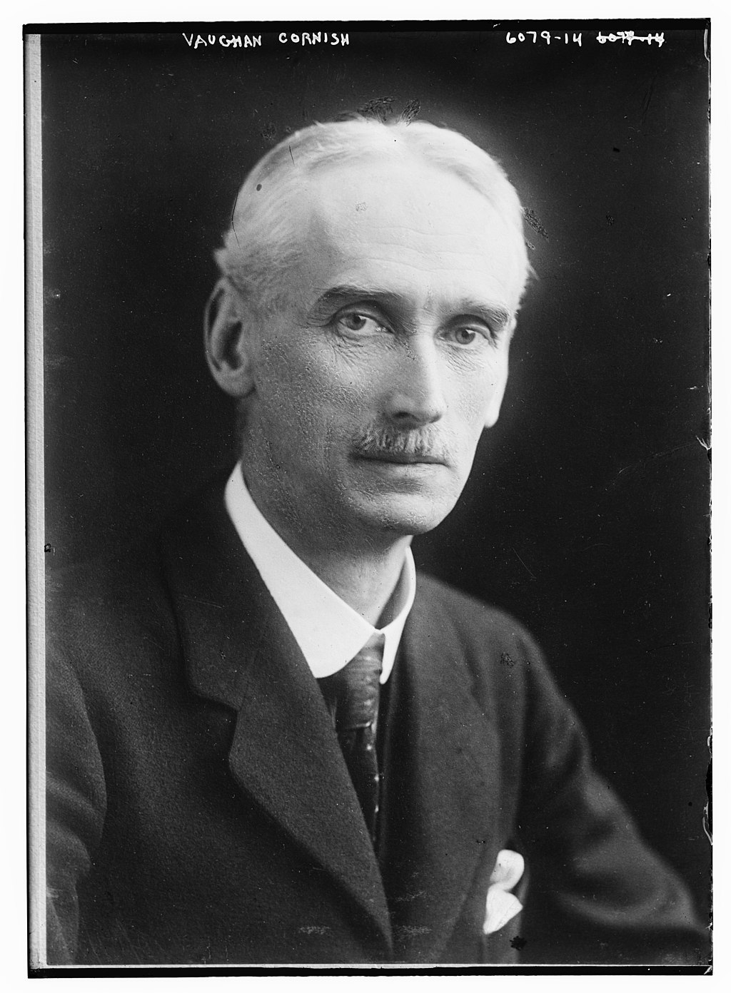
1928: Dr Vaughan Cornish

Last updated October 2023

1928 saw another President with a notable geographical pedigree take office.

Dr. Vaughan Cornish is someone I have been aware of for many years, and who has been described as one of the most prolific geographers of all time.

He was born in Debenham in Suffolk in December 1862, the third son of a vicar.

He was unusual when compared to many other of the early GA Presidents in that he never held a university post of any kind. This has remained relatively rare.

He was later selected by Carl Sauer as one of six geographers whose readings would provide a 'truly liberal geographic education', and was a worker of wide interests and versatility
Andrew Goudie (also GA President)


The other reason I am familiar with Cornish is through his association with Sidmouth, a town I have visited regularly for many years. He is buried in Salcombe Regis, just outside of the town.

When I was working for the Geographical Association, I was interested to see what was down in the GA collections and archives in the basement. In my lunch hour, I used to poke around in the filing cabinets partly to see what potential there was to unlock value in the objects the GA holds, but also to seek inspiration for my own projects. I came across some lantern slides, which I don't think were from the original collections from the original founding of the Association, as they were too new, but nonetheless interesting. One of the things I did find in one of the rooms was a series of large framed prints.
These were beautiful, and featured a range of subjects, including wave forms. They had lovely hand written captions and were signed by Cornish.


Image: Alan Parkinson - shared under CC license

Waves were one of the areas that Cornish had explored in detail. He studied waves, wave forms, and processes.
He was also the first British geographer to study dune formation and form, including desert dunes and sand dunes. It was this that drew him to the attention of Andrew Goudie (a future GA President).

In the late 1890s and the start of the 1900s, Cornish was active in delivering lectures.

These are described in a large section of Emily Hayes' PhD - this has been blogged about previously.

There were also some prints of images of the Kingston Earthquake, which I knew that Cornish had experienced in Jamaica in 1907. This was one of the journeys that he took with his wife Ellen.

I have a few of his books, including 'The Beauties of Scenery'. This describes his ideas on the aesthetics of landscape, and the involvement of people.
My copy is pictured here, a hardback 3rd edition from 1944. The book has the subtitle 'A geographical survey', and was started in 1920, following Francis Younghusband's Presidential Address to the RGS, when he said that it was the duty of geographers to undertake the analytical study of beauty in scenery'.

Here's a list from his Wikipedia entry - I have copies of the books in bold. The GA holds copies of some others in their archive / Fleure Library.
  • The Panama Canal and its Makers (1909).
  • Waves of the Sea and other Water Waves (1910).
  • The Travels of Ellen Cornish: being the Memoir of a Pilgrim of Science (1913).
  • The Waves of Sand and Snow (1914).
  • Naval and Military Geography (1916).
  • Imperial Military Geography (1920).
  • A Geography of Imperial Defence (1922).
  • The Great Capitals (1923).
  • National Parks and the Heritage of Scenery (1930).
  • The Poetic Impression of Natural Scenery (1931).
  • The Scenery of England (1932).
  • Borderlands of Language in Europe (1933).
  • Ocean Waves and Kindred Geophysical Phenomena (1934).
  • Scenery and the Sense of Sight (1935).
  • The Preservation of our Scenery (1937).
  • The Farm upon the Cliff (1939).
  • The Scenery of Sidmouth (1940).
  • Historic Thorn Trees in the British Isles (1941).
  • A Family of Devon (1942).
  • The Beauties of Scenery (1943).
  • The Photography of Scenery (1946).
  • Geographical Essays (1946).
  • The Churchyard Yew and Immortality (1946).
  • Kestell, Clapp and Cornish (1947).
  • Sketches of Scenery in England and Abroad (1949).
Cornish's images were widely exhibited too - one of the images that I came across had this label on the back:


Image: Alan Parkinson - shared under CC license

Cornish also studied the aesthetics of landscape, and the work on the beauty of landscape is one of the areas that he is best known for.
A biography and appreciation of Cornish was written by a future GA President (who will appear in a future post) Andrew Goudie, and can be read on JSTOR (a free account can be created for those who want to read it).


Cornish's acceptance of the invitation to be President was announced in 'Geography' in 1927.


Cornish's Presidential Address in 1928 was on the theme of Scenery of course, and was called 'Harmonies of Scenery: An outline of Aesthetic Geography'. It is beautifully written and contains a great deal of sense on how the landscape could be viewed.


Cornish laid out his theory of aesthetics, which started with the Scenery of Civilisation, drawing on his childhood in Debenham, Suffolk, in a parish which was "Nature adapted to Man's needs and flourishing under his care".

"Rural England owes much of its Arcadian charm to the fact that form and movement and colour are a decorative scheme which harmonises with the quiet continuity of the least changing of industrial pursuits. It is a country of gentle undulations where rivers flow quietly in winding curves, a land well timbered by deciduous trees of rounded form, of fields divided by a bushy fence, all in a climate of soft skies, where the song of birds is heard throughout the year...."

However, this Arcadia is easily broken...

"...by buildings of harsh form or staring colour, or by clatter of mechanical noise..."

In 1930, Cornish was still active in the GA, and was involved in some work around potential plans for National Parks. 
At this time, he was a Director of Technical Education in Hampshire, but resigned in 1933 to concentrate on his work.

He gave his ownl land, near Salcombe to the National Trust.


As mentioned earlier, Cornish was also a great proponent of National Parks. These finally came into being after an Act of 1949, and the Peak District was the first in 1951. In 1930, Cornish proposed his own National Park areas, some of which eventually became National Parks. He was well ahead of the game with Broadland for example.


His support for coastal protection was also well known.
This was outlined in a piece in 'Geography' at the time.


I came across a blog post from his home village of Debenham, which referenced a number of obituaries printed in The Times.

Obituary - Death of Dr. Vaughan Cornish (from The Times, 3rd May 1948)

We regret to record the death of Dr. Vaughan Cornish, which occurred at Camberley on Saturday at the age of 85 years. Dr. Cornish was a member of a well-known local family whose association with the district began in 1792. He was a great traveller and geographer and was particularly proud of his connection with Salcombe Regis. When the Sidmouth Council purchased the greater part of the land on the eastern side of Salcombe valley to prevent the establishment of a holiday camp there, Dr. Cornish gave a good deal of his land on the western side of the valley to the National Trust in order that its natural beauty should be preserved for all time.

He was a great lover of natural beauty and in spite of his wanderings it was always to Salcombe Regis he returned for refreshment and he never tired of singing its praises. With his first wife he was in Jamaica at the time of the great earthquake there and has broadcast about his experiences at the time.

During recent years Dr. Cornish has published many books, chief among them being "The Scenery of Sidmouth" which is a classic in the description of the local land- and seascape. His most recent book "Kestell, Clapp and Cornish," was lately reviewed in these columns, and as a great deal of it is autobiographical we commend it to our readers at this time.

Dr. Vaughan Cornish was buried at Salcombe Regis yesterday afternoon.


A second obituary was also published.

Obituary - Death of Dr. Vaughan Cornish (from The Sidmouth Observer, 5th May 1948)

One of Britain's best-known geographers, Dr. Vaughan Cornish, D.Sc., F.R.G.S, of "Inglewood," Gordon-road, Camberley, died on Saturday at the age of 85, in a Camberley nursing home. Dr. Cornish, who is survived by his widow, was famous among geographers for his studies of land and water waves. In later years he gave much of his time to the appreciation and preservation of the natural beauties of Britain. He had lived in Camberley since 1913.

He was a student of geography in all its aspects, and he was an author of ability who illustrated his works with his own sketches and photographs.

Dr. Cornish was born at Debenham Vicarage, Suffolk and was educated at St. Paul's School and at Victoria University, Manchester. He graduated with honours in chemistry in 1888 and later took the degree of D.Sc. He became Director of Technical Education to the Hampshire County Council, but after his marriage he entered the field of geographical scientific research. In 1900 the Royal Geographical Society presented him with the Gill Memorial for his research work into all types of waves, both on land and sea, on snow and sand and natural materials.

A world tour by Mr. and Mrs. Cornish in 1903 was the occasion for a great deal of important scientific work, and was followed by visits to many parts of the world. They were injured at Kingston, Jamaica, in January, 1907, when an earthquake wrecked the city and killed many of its inhabitants. A few months later they returned to Kingston to study earthquake effects.

During the first world war Dr. Cornish lectured to naval and military officers on strategic geography and subsequently published a number of books. He remained an active author until recently.

The funeral took place on Tuesday at Salcombe, Devon.


The GA obituary can be viewed from the link below.


T. C. W. “OBITUARY: DR. VAUGHAN CORNISH.” Geography, vol. 33, no. 3, 1948, pp. 149–150. JSTOR, www.jstor.org/stable/40564419.

One final point, from Andrew Goudie's piece is that he described himself in Who's Who as a geographer.

References

Source: Goudie, Andrew. “Vaughan Cornish: Geographer (With a Bibliography of His Published Works).” Transactions of the Institute of British Geographers, no. 55, 1972, pp. 1–16. JSTOR, JSTOR, www.jstor.org/stable/621720. 


From his Wikipedia page
Source: https://en.wikipedia.org/wiki/Vaughan_Cornish
Also provided the image of Vaughan Cornish.

I amended the entry to show that he was the GA President. I think he would have appreciated that.

Cornish, Vaughan. “ON RHYTHMIC MOTION IN RIVERS. A STUDY IN SCENERY.” The Geographical Teacher, vol. 13, no. 4, 1926, pp. 276–284. JSTOR, www.jstor.org/stable/40556129.
Emily Hayes: 'Geographical light: the magic lantern, the reform of the Royal Geographical Society and the professionalisation of geography c.1885-1894
https://www.sciencedirect.com/science/article/pii/S0305748817300427

Thesis:
https://ore.exeter.ac.uk/repository/handle/10871/23096

Matless, David. “Nature, the Modern and the Mystic: Tales from Early Twentieth Century Geography.” Transactions of the Institute of British Geographers, vol. 16, no. 3, 1991, pp. 272–286.

JSTOR, www.jstor.org/stable/622948

Cornish, Vaughan. “NATIONAL PARKS-THE CLAIM OF THE COAST.” Geography, vol. 15, no. 5, 1930, pp. 384–387. JSTOR, www.jstor.org/stable/40559155.

Goudie, Andrew. “Vaughan Cornish: Geographer (With a Bibliography of His Published Works).” Transactions of the Institute of British Geographers, no. 55, 1972, pp. 1–16. JSTOR, www.jstor.org/stable/621720.


If anyone has further information on the contributions made by Vaughan Cornish to the Association, please get in touch.

Updated August 2021
He took many lantern slides and we have found some in the 'Geographer's Gaze' project.

While searching some images of these I came across this paper by Emily Hayes, who I had previously been in touch with.

It describes Cornish as a eugenicist geographer and landscape heritage activist.
Here is Cornish writing on the Geography of eugenics. An address given in Toronto in 1924, before he became the President of the GA.
Klaus Dodds has also written about Cornish and eugenics.

The Debenham parish heritage site here provides a great deal of further family information on Vaughan Cornish.

From the New York Times - Monday May 3rd 1948

Updated July 2022
There are some of Cornish's writings and views which are problematic and link to ideas of eugenics - he is not alone in those amongst GA Presidents of the early 20th Century.


Emily Hayes, who features elsewhere on the blog, has written about Cornish.

Updated August 2023

The Public Domain Review article here has a link to his work on waves, and also an embedded copy of the books he wrote. It focusses on his work as a kumatologist: a term he coined for someone who studies waves.

Walking along the Devon coast at low tide in the autumn of 1895, geographer Vaughan Cornish (1862–1948) watched two sets of waves interact on the shore. As one set rippled across the flat strand, the other rounded a shoal and broke onto the beach. After colliding, each set then continued on its separate path, which brought to his mind how waves of light can pass through each other unaffected. Cornish’s casual association, between the behavior of light and water, speaks to how immersed he and his contemporaries were in a world of invisible waves.

American geographer Carl O. Sauer considered Cornish one of but four predecessors who could serve as a master for twentieth-century geographers.

Liberated from the need to work by his wife Ellen’s inheritance, the couple traveled around the world studying Earth’s variegated waveforms. Experiencing a catastrophic earthquake together in Kingston, Jamaica in 1907, they saw a familiar pattern: uniformitarian agency operating across crests and troughs. The pair subsequently traveled to the Panama Canal to understand waves in the volcanic bedrock, and in 1913, after Ellen’s death from cancer, Cornish penned a tribute to her scientific companionship: The Travels of Ellen Cornish. Being the Memoir of a Pilgrim of Science.


Check out Robert MacFarlane's 'The Wild Places' for a mention as well. 

I'll finish with a quote from Cornish on waves...

Most of us have felt the fascination of the wave. 
The waves of the sea, which are the prototype of all the phenomena which we now call waves, are perhaps the most fascinating of all. Great as is the beauty of their form, the mystery of their motion is the greater charm. For while they move they live and have a being, which, like our own, is but momentarily associated with the matter of which they are formed. The wave preserves its individuality, it’s recognisable through not unchanging form, its energy, party active, partly in reserve, whilst its material substance is constantly rejected and renewed. Of all manifestations of the inorganic world it is most like a living being. Yet when we watch it to its end we find none of the sad accompaniments of the exhaustion of life. It is at its most beautiful at the last, as it culminates to its fall and breaks in seething form.

From 'The Guardian'


I also found reference to his work on Section E of the BAAS


Source:
Beaver, S. H. “Geography in the British Association for the Advancement of Science.” The Geographical Journal, vol. 148, no. 2, 1982, pp. 173–81. JSTOR, https://doi.org/10.2307/633769. Accessed 24 Aug. 2023.

Updated October 2023

He undertook to preserve the land around Salcombe Hill (1937)


He features in a book on Pioneers of the Jurassic Coast


A book on the Devon Cornishes....


An article on Vaughan and his two brothers:


I perhaps need to get here too:


Updated November 2023

Cornish travelled with his wife Ellen. He wrote about their travels in 1913. She died in 1911.


Journal of the Royal Society of Arts, vol. 61, no. 3141, 1913, pp. 297–297. JSTOR, http://www.jstor.org/stable/41340507. Accessed 1 Nov. 2023.

Margaret Mackintosh RIP

Updated post. Sad news at the end of last week from colleagues who have organised the Charney Conference over the years of the passing of Ma...