Showing posts with label Land Utilisation Survey. Show all posts

Sunday, 26 November 2023

Domesday Discs - 1986

The BBC's Domesday Disc project appeared in 1986.

It involved students collecting data, and adding to a digital laser disc the size of an old LP, which was read using a special reader, and navigated using a tracker ball which could be rotated by the hands. The final product was quite costly to purchase - a real investment for a school. I believe the price included the BBC Micro that was required to run the associated software and hardware.


Initially estimated to require the involvement of 10,000 schools and about one million children, the intention was to make the role of schools central in a data gathering project that would assign each school to a geographical area, have parents and local societies collect data, with the schools "acting as a focus and providing the computer". Questionnaires about geography, amenities and land use were to be completed, with school pupils and other contributors also able to write about their local area and "the issues affecting them" in their own words

Source: Wikipedia

As with the Land Utilisation Surveys of Stamp and Coleman, students were involved in its production and data collection, and it was a BBC project aimed at commemorating the 900th anniversary of the original 'Domesday' survey of 1086 ordered by William the First of England.

I still have one of the discs - although not the player and tracker ball to make use of it. There was an also an EcoDisc based on Slapton Ley which we also had in my geography department.

This website provides further details on the project.

There is an article from former GA President Margaret Roberts on the use of the Community Disc in an issue of 'Teaching Geography' from 1990. An early contribution to TG from Margaret.


I remember some external organisation coming in and filming me demonstrating the discs - I wonder what that was for, and whether it still exists somewhere - it would be wonderful to see it as I was fresh into my teaching career....


References:

Roberts, Margaret. “Locations, Lines and Areas: Exploring the Community Disc in the BBC Domesday System.” Teaching Geography, vol. 15, no. 1, 1990, pp. 17–18. JSTOR, http://www.jstor.org/stable/23752172. Accessed 23 Sept. 2023.


Some of the resources that came from the project:

Research Paper (Open Access)

https://www.researchgate.net/publication/232993632_The_Domesday_Project--an_educational_review


The BBC later produced two further discs: an EcoDisc and one on Volcanoes.

I remember seeing them both - and also the very detailed instruction manuals.

A web based version existed for a while with an update for places in 2011. It's now on the National Archive site.

And a video of it in action:

Keen to hear from anyone who has memories of using the BBC Domesday Discs.

Tuesday, 3 October 2023

A Modern Domesday Book: the Land Utilisation Survey of Dudley Stamp

A website section on the LSE website which appeared in June 2023.

It's written by Anna Towlson to go with an exhibition of mapping earlier in the year (which I missed completely). She works at the LSE.

A reminder that Dudley Stamp was GA President in 1950, well after he started work on the survey. He was also a million selling textbook author.

It outlines the background to the survey:

Sir Dudley Stamp’s aim was to undertake a detailed field-by-field survey of England, Wales and Scotland to find out exactly what the surface of the land was being used for. The idea grew out of his work as Chairman of the Regional Studies Committee of the Geographical Association in the late 1920s. British agriculture had been facing a long and severe depression, mainly because of the increase in world food supplies and competition from cheaper producers. Many towns and cities had been growing at a steady rate since the industrial revolution, with low profits and low wages in the countryside speeding the drift of labour from the land.

Stamp envisaged the Survey as acting as, in his phrase, a “modern Domesday Book”. This comparison caused some confusion at the time, in that it led some people to think that the Survey was part of a large tax-gathering exercise. But in many ways it is very apt: it was a comprehensive national survey that was designed to be of contemporary use as an administrative tool, but it also formed a permanent record of the country’s landscape at a particular time, something that is now of enormous historical value.

Stamp envisaged that much of the field work would be done by volunteers, mainly children from local schools and colleges. He also saw the project as a national educational exercise, an opportunity to interest young people in their local environment, to develop their observational and map reading skills, and to give them what Stamp called “a training in citizenship”, with each region playing its part in a nationwide scheme.

Few people had the profile and the force of will of Stamp to pull off such an ambitious project.

In autumn 1930 he contacted the directors of education in counties across the whole of Britain to explain the project and ask them to coordinate work in their areas. He then spent the next year touring the country to talk to head teachers and education committees and taking out parties to demonstrate field work methods. He estimated that in this first year he covered almost 2,000 miles a month, with his wife acting as chauffeur. By mid-1931, the Survey was underway in most counties in England, and by early 1932 in Wales and Scotland also.

Consider these statistics:

Stamp estimated that there were about 20,000 sheets to cover, with each sheet taking two to three days to complete. Field surveying started in October 1930, but most of the work was done between 1931 and 1934. During this period Stamp continued to tour the country extensively, meeting with local officials and offering encouragement to field workers. The Survey also issued regular bulletins to the volunteers to keep them informed on the progress of the project as a whole and to clarify questions or problems with the surveying.

By January 1932 some 400 sheets had been returned, and by January 1934 this had risen to over 15,000. The bulk of the fieldwork was finished by the end of 1935, with a flying squad of surveyors, mainly geography students or former geography students from London University, finishing off remoter areas that local volunteers could not cover. This stage of the project was clearly an enormous undertaking and by the end Stamp estimated that it had involved about a quarter of a million school children, as well as teachers and other adults.


One of the key people in the survey, and much forgotten is Eunice Wilson.

She is pictured in the blog post.

Eunice Biki Wilson, 1984. IMAGELIBRARY/755. LSE.

She started at the LSE as a cartographic assistant on the LUS. It was an interesting post that soon absorbed her talent and imagination and she rapidly developed skills that made her a pioneer of cartographic illustration. As new applications were found for the LUS in the field of land use planning, and as its work intensified, Biki eventually found herself as Chief Cartographer in charge of a new drawing office attached to the Land Use Division of Ministry of Agriculture

The survey results proved their value during and after the Second World War.

NLS has maps of Scotland and elsewhere.

The very last area to be surveyed was part of the Isle of Arran in September 1941, although all other areas were recorded by 1939. The surveys were extensively cross-checked by the team, even including Stamp with his wife as chauffeur: ‘I must have covered thousands of miles myself, often standing up on the front seat of my car with my head through the sunshine roof and a roll of six-inch maps in front of me’ (Stamp, 1948). The maps were also cross-checked with adjacent sheets when reduced to the one-inch scale.

Here's the map that features my village in Norfolk


Sources:

Stamp L.D. (1931). 'The Land Utilization Survey of Britain'. The Geographical Journal, 78, 40-47.

Stamp L.D. (1948, with later editions in 1950 and 1962). The Land of Britain: its use and misuse (Longman, London).

Monday, 18 September 2023

Dr Edward Christie Willatts OBE

Another unsung hero, linked with the work of Dudley Stamp and the Land Utilisation Survey but a great deal more besides.


Image from the 1930s. Could that be Edna Green too?

Image source: https://www.flickr.com/photos/lselibrary/3983645366/in/photolist-752dYN

Edward Christie Willatts, geographer and cartographer, born July 4 1908; died January 8 2000

Christie Willatts, who has died aged 91, was recruited by the wartime government to run a geographic information system in the days before the term itself was invented. He was well qualified to do so. He had been the organising force behind Britain's first land utilisation survey. From 1941, until his retirement in 1973, he used his energy, unrivalled knowledge and skill as a presenter of geographical facts, to help planners and decision-makers across Whitehall do their job better.

Professor Dudley Stamp recruited him to run the survey he had conceived of land-use across Great Britain. Willatts recruited and enthused thousands of volunteers, writing their instructions, supplying their maps, and then checking the results. 

He did this by travelling the country by motorcycle and sidecar with fellow geographer Edna Green, whom he married in 1937. 
When the government requisitioned the survey offices at LSE, he commandeered a barrow to wheel all the maps and records to Bacon's, their printers in nearby Fetter Lane. When these were blitzed, Willatts set up a drawing office in his own home.

The Royal Geographical Society awarded him the Gill Memorial in 1950 for research, and he was appointed an OBE in 1958. He helped to found, and later became an honorary member, of the British Cartographic Society.

Source:

Obituary from 2000: https://www.theguardian.com/news/2000/mar/17/guardianobituaries4

He also helped J A Steers with his survey of the coastline of England and Wales.

His Obituary in 'Geography' was written by GA President Professor Michael Wise

Willatts had trained as a teacher 1930-31 and, at a time when good teaching posts were difficult to find, had received an attractive offer from Hulme Grammar School, Manchester. As he was already undertaking fieldwork for the LUS in Surrey, Willatts seized the new opportunity offered by Stamp for a year at an annual salary of £200. The decision brought great good fortune to the LUS. Willatts' work involved visiting education officers to win support, recruiting schools and student volunteers to undertake the field work, writing and publishing leaflets and instructions, supplying the six inches to the mile quarter sheets, collating and analysing the completed sheets, arranging the publication of the one-inch maps and, later, the production of the County Reports.


Source:

“Dr E.C ‘Christie’ Willatts, OBE 1908-2000: An Obituary.” Geography, vol. 85, no. 2, 2000, pp. 166–166. JSTOR, http://www.jstor.org/stable/40573410. Accessed 16 Sept. 2023.
E. C. Willatts (1946) "Some Geographical Factors in the Palestine Problem" The Geographical Journal,Vol. 108, No. 4/6 (Oct. - Dec., 1946), pp. 146-173 (32 pages)
J. R. James, Sheila F. Scott, E. C. Willatts (1961) "Land Use and the Changing Power Industry in England and Wales", The Geographical Journal, Vol. 127, No. 3 (Sep., 1961), pp. 286-309
E. C. Willatts (1971) "Planning and Geography in the Last Three Decades" The Geographical Journal, Sep., 1971, Vol. 137, No. 3 (Sep., 1971), pp. 311-330

Other references:


A piece in the BCS journal:


Christie Willatts inspired and helped to train almost an entire generation of cartographers at a time when there were no formal qualifications in the subject outside geography and surveying. Forced on him by the wartime situation he recruited many young women some straight from school and who count themselves fortunate to have had such a teacher. Having begun his postgraduate career by training as a teacher and having held parttime university teaching posts at LSE and Birkbeck College in London, his role became one of combining research with trainingwithin the Civil Service. His national contribution lay (with Dudley Stamp) in the completion of the aims of the LUS, then of laying the groundwork for a national atlas and lastly of raising the profile of geographical cartography in Britain, with decisionmakers and national institutions.

Friday, 22 May 2020

1966: Professor Stanley Henry Beaver

Last updated August 2023

Professor Stanley Henry Beaver was an academic geographer, who was particularly associated with the LSE and Keele University, as well as being a great supporter of the work of the GA.

A prolific author, he authored books on a wide range of topics, from Sand and Gravel, to more general human geographies of the world, and geomorphology.
He had a very long association with the GA, as did many Presidents of course, working with them for over 30 years before becoming President in a number of roles, and providing content for journals.
He was involved with L Dudley Stamp's Land Utilisation Survey, and co-authored many of the reports that came out of that survey in the 1930s and beyond.

He also became involved in the planning and delivery of the Annual Conference in 1933, after Dr. H J Wood stood down.
During the 1930s, the GA Conference actually moved around a lot more than it had previously, where it was mostly held at the LSE. The 1930s saw it in cities including Liverpool, Glasgow, Nottingham and Sheffield. In 1932, the conference was even planned to be overseas in Heidelburg, but political and currency problems meant it had to be cancelled.

He had an association with the RGS (as many other GA Presidents have) and the IBG.

When he left the LSE he was succeeded by Michael Wise: another former GA President.

He also co-wrote a classic book with another GA President, L Dudley Stamp called 'The British Isles' as part of the 'Regional Geography' series.

He was born in London in 1907, and went to UCL where he graduated with first class honours in Geography in 1928. He completed his Diploma in Education in 1929, and according to an obituary published in the Transactions of the IBG, was influenced by L. W. Lyde, who apparently regarded geography as:
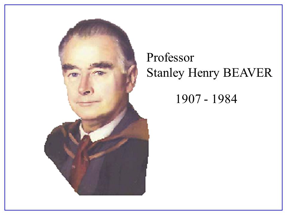
Image result for Professor Stanley Henry Beaver
"a body of knowledge coupled with an attitude of mind". 

He worked at the LSE between 1929 and 1950,  along with L Dudley Stamp

For some time, I couldn't find a contemporary image of Stanley Beaver, but was fortunate to receive one from Dr. Philip Kivell which can be seen at the top of the blog post.

In 1962, he had a piece published in 'Geography' on the Le Play Society and their contribution to fieldwork.

By this time, he was Head of the Geography department at the University of Keele. He stayed at Keele until his retirement in 1974 when he became Emeritus Professor.


In it, he references the work of Patrick Geddes, who had A. J. Herbertson as his assistant.


I am grateful to Dr. Peter Knight for helping me get in touch with Dr. Philip Kivell, who very kindly gave me a range of additional details on Professor Beaver's career and personal life. 
What follows was provided very kindly by Dr. Kivell.

S.H.BEAVER 1907-1984
Stanley Henry Beaver was born in Willesden, North London in August 1907. He graduated from University College London in 1928 with first class honours in Geography having already been awarded the Morris Prize and a University Scholarship in Geology. His first academic post was at the London School of Economics, where a very productive period resulted in appointment as Ernest Cassel Reader in 1946. His major work at this time, together with L Dudley Stamp was “The British Isles: a geographic and economic survey” which went though many editions before and after the war and provided a geographical grounding for  many thousands of students. 
During the war he worked for Naval Intelligence and used his geographical training to produce a number of regional handbooks. 
He was appointed as the founding professor of Geography at the new University College of North Staffordshire, subsequently Keele University, in 1950. 
Here he built up the first new post- war Geography Department in the country, including being closely involved in the physical design of the building. 
This included finding a home for millions of RAF air photographs taken over Europe during the war, and the establishment of a meteorological station on the campus.
Beaver could fairly be described as a traditional geographer, a product of an age that largely pre-dated the increasing specialization that reshaped the discipline from the 1960s. 
Having said that, his interests and skills were enormously diverse.  Most obviously he was a Human Geographer concerned with economic and regional matters, but his interests also ranged widely over transport geography, land use and dereliction and he was equally well informed about climate, meteorology, and mineral extraction. He was a practical academic, always interested in how environments and human processes worked and in this context he helped enormously to put “The Potteries” region on the map of public and academic awareness.
He was a superb and well organised teacher and was always in demand as a guest speaker by organisations across the country. From a student point of view he was extremely well respected but perhaps not the most approachable teacher. He belonged to an era when staff- student relations were more formal and respectful so the informality and student politics of the 1960s and 70s did not always sit easily with him. 
He could appear austere and remote but those who experienced his excellent field excursions soon saw a more relaxed side of him and were perhaps party to his dry sense of humour, his love of puns and his stock of limericks. At heart he was kind and immensely supportive to his staff and colleagues.
Apart from his teaching and research Beaver played a very active role in numerous groups and committees. Some of these were tied up with the University and local region, but others were national or international.  For many years he chaired Keele University Grounds Committee, responsible for the largest, and some would say, most attractive university campus in the country. It was not unknown for him to open his office window to berate students who were walking on the grass. 
He was President of the Geographical Association, active in the RGS and in the founding of the IBG, the IGU and the Anglo-Polish seminars. 
As Chair of the Geography Board of the CNAA he played a major role in promoting the new Polytechnic sector. Amongst all of this he found time to translate several important French texts into English.
During his quarter century at Keele  Stanley lived on the campus with his wife Elsie, who also worked as curator in the departmental map library, and four children. He enjoyed his large garden which he said (tongue in cheek) lay astride the watersheds between the Trent, Severn and Weaver catchments. One of his enduring passions had been steam railways, about which he was enormously knowledgeable. When the locomotive Keele Hall was withdrawn from service in 1963 Stanley Beaver bought the nameplate and displayed it proudly in his new department. On numerous overseas travels he would manage to arrange a trip on the footplate of whatever local steam locomotive took his fancy.
Upon retirement he and Elsie bought a large house in Eccleshall , a few miles from the campus, where he continued to garden, to enjoy his stamp collection and to continue his involvement in local Staffordshire organisations, especially the CPRE. He and Elsie endowed separate funds for student prizes and for fieldwork in the local area. 
Stanley Beaver was undoubtably one of the great geographers of his generation.
Professor Beaver died in 1984.

References
http://worldcat.org/identities/lccn-n50006237/

Obituary: “Stanley Henry Beaver, 1907-1984.” Transactions of the Institute of British Geographers, vol. 10, no. 4, 1985, pp. 504–506. JSTOR, www.jstor.org/stable/621896

Beaver, S. H. “The Le Play Society and Field Work.” Geography, vol. 47, no. 3, 1962, pp. 225–240. JSTOR, www.jstor.org/stable/40565418

British Geography 1918-1945, Edited by Robert.W Steel - published in 1987.
Chapter 12 was by J A Patmore, where he gave a personal perspective on the period.

Article in Geography in 1978
BEAVER, S. (1978). Some Observations on the Climate and Weather of New Zealand. Geography, 63(1), 14-22. Retrieved August 25, 2020, from http://www.jstor.org/stable/4056883
Patmore describes Beaver in this chapter.
A chapter in this book is here:
https://books.google.co.uk/books?id=9NSDx4DxfVcC&lpg=PA76&ots=uk5vMrcPG4&dq=stanley%20henry%20beaver%20geographer&pg=PA76#v=onepage&q&f=false

RGS Archives: http://discovery.nationalarchives.gov.uk/details/c/F46114 - I won't be able to visit the archive for a while, but there are quite a lot of papers

Updated - May 2020

A few updates to add following the posting.

There was a connection revealed between Professor Beaver and another former GA President who will have his own entry in due course (sometime in 2021) Bob Digby.
Bob told me that:


Bob apparently spent the £25 in the Keele University bookshop, buying geography textbooks from the time.

I also discovered another bit of information on Professor Beaver, from when he was a student at UCL in the 1920s. He was taught by Lionel William Lyde, another high profile Geographer from the early part of the 20th century.

His wife Elsie Rogers was also a student at UCL, and her memories of Lyde's teaching were also featured in the same document.


Taken from UCL Geography Department Archives.

Keele University offers an Elsie Beaver Prize for the best undergraduate dissertation by final year student involving fieldwork in physical geography, so the connection to Beaver continues.
It seems that she worked in the Map Library at the University as Map Curator. 


Beaver was also taught by another former GA President: Edmund Garwood. More connections...

Source:
https://books.google.co.uk/books?id=7BQSBwAAQBAJ&lpg=PA16&ots=qyoQUQmILd&dq=lyde%20geography%20definition&pg=PA8#v=onepage&q&f=false
- this link is to one of the many Biogeographical Studies, which are 'proper' versions of what I'm doing on this blog.

I also found his own entry, after all that, in the Biogeographical Studies series.


This included an image of him, and also details of his links with the GA, as well as a lot more detail.

Beaver was Honorary conference organiser from 1934-1949 and also declared an intention to visit every branch in Britain while President - something I hoped to do, but didn't quite manage it.


https://books.google.co.uk/books?id=R-48DwAAQBAJ&lpg=PA130&ots=vx3Y5ASsYg&dq=lionel%20lyde%20UCL&pg=PA129#v=onepage&q=lionel%20lyde%20UCL&f=false 

As always, if you have further information relating to this President please get in touch. 

Thanks to Dr. Philip Kivell for the image of Professor Beaver used at the top of the blog and substantive text later on.
Thanks to Dr. Peter Knight for his assistance as well.

Updated March 2023

Mentioned on first page of J B Priestley's 'English Journey'.

Updated August 2023


This flagged up his involvement with Section E of the BAAS, which I have been investigating over the last few days and have found plenty of details in the Transactions of the IBG and elsewhere that show Beaver's substantial involvement in discussions around geography in schools and universities. 


GA Obituary

Rodgers, H. B. “The Geographical Association.” Geography, vol. 70, no. 1, 1985, pp. 77–80. JSTOR, http://www.jstor.org/stable/40571501. Accessed 24 Aug. 2023. 

Thursday, 15 August 2019

1930s: Land Utilisation Survey

The GA established a Regional Survey Committee in the 1920s and running into the 30s when it worked on finalising the Land Utilisation Survey.
This was instigated by Laurence Dudley Stamp, who was to become GA President later.

He had previously completed other land use work, and was interested in the publication of a map of Northamptonshire, published by the OS after the work of a geography teacher called Mr. E. E. Field.

Dudley Stamp according to 'Billy' Balchin, "was quick to realise the potential value of a national Land Utilisation Survey for GB as a whole and immediately proposed through the GA committee the establishment of a central organisation at the LSE"

This had representatives from the GA, OS, Ministry of Agriculture and Education Authorities. The GA couldn't afford to fund the survey, and in 1930, it became a separate Association under the Directorship of L Dudley Stamp.

During the 1930s, the survey continued, with the rural areas being easier to complete. The Six Inch survey was completed first, followed by the One Inch survey, funded by county sponsorships and help from individual LEAs (remember those?)

The survey was carried out by teachers, pupils, Scouts and Guides, students, WI members and even nuns. Those involved were convinced that if the land could be used better, Britain would be better - some great pre-War optimism.
Once the surveys were undertaken, the maps were returned to the office. They were transcribed by hand, and Dudley Stamp went out to many parts of the country to check them for accuracy. The Survey was funded by the royalties from Stamp's books. As the maps from the survey were published, Stamp wrote memoirs for each county that had been covered.

Stamp estimated, according to Rex Walford, that a quarter of a million schoolchildren were involved in the Land Utilisation Survey. It was later repeated under the helm of Alice Coleman (more on that to come in a later blog post), and finally in 1996 (more on that to come later too). James Fairgrieve (another former President was also involved according to Fleure's reports on the Survey in 1953
The layer was made available online, so it can be accessed.
It can be seen in the Visions of Britain website.

Here is the layer for Ely, for example.


Some sections of the country have a more 'hand-drawn' look to them.

A later survey was featured in a piece by Rex Walford which I have blogged about and will appear here in time.

Reference
Rex Walford (2001) - Land Utilisation Survey is featured in detail on pp. 108-112

Stamp, L. Dudley. “THE LAND UTILISATION SURVEY OF BRITAIN.” Geography, vol. 16, no. 1, 1931, pp. 44–51. JSTOR, www.jstor.org/stable/40557799.

Fleure, H. F:  (1953) https://www.jstor.org/stable/40564702 "Sixty years of geography and education"

Margaret Mackintosh RIP

Updated post. Sad news at the end of last week from colleagues who have organised the Charney Conference over the years of the passing of Ma...